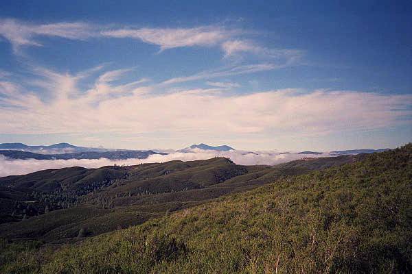
The Hike: The hike starts at the parking area, and the trail is through the posts to the right. The trail parallels highway 20 for a bit, then turns sharply to the left, back up the canyon. Since this is also the trailhead for the cache creek ridge trail, make sure you take the westernmost trail, and not the fire road. It will climb until it intersects with an old fire road. You follow this old fire road all the way to Cache Creek. The hike is very open, and the views are fabulous. As you look down the trail, you are looking toward the Wilson valley area. This area is the heart of the Cache Creek wilderness study area. Along the way, there are several oak groves at which to stop, relax, and have a snack. Cache creek is impassable during high water, so the creek marks the end of this trail. If the water is low enough, you can get to the Wilson Valley and continue on the Redbud Trail. Distance: 5 miles, one way, from the Highway 20 trailhead to Cache Creek. Total elevation gain of 1425. If you are doing this as a backpack trip, it is another 6.2 miles to the Redbud trailhead parking area from Cache Creek. |
How to get there: From Yolo county, Woodland and Davis, take Highway 16 up the Capay valley. Once you pass the town of Rumsey, you begin to enter the Cache Creek Canyon. The road will narrow and you will be driving with the creek on one side and the canyon walls on the other. Continue on Highway 16 until you reach Highway 20. Make a left on Highway 20, and the road will begin to climb uphill. After a while, the road will begin to drop down again. Keep your eye out for the 46.07 mile marker, and the parking area on the left of the road. The parking areas is just at the point where the road starts to level out from the downhill portion. |
| Photos | |||
 |
 |
||
 |
 |
||
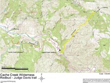
| Map with trail route highlighted (.pdf file) |
 |
GPS track of trail route only (.gpx format) |
 |
| Map without highlights (.pdf file) |
 |